copyright © 2023 PT Global Sukses Digital
Explore more with this rugged handheld that offers optimal tracking accuracy, a 2.6-inch colour display and preloaded maps.
![]()
Don’t miss a detail with this large, sunlight-readable colour display.
![]()
Lead the way in challenging locations with multi-band technology and expanded GNSS satellite support.
![]()
Cross the countryside with routable TopoActive maps.
![]()
Plot your next move with built-in navigation sensors.
![]()
Organise your adventure from anywhere with the Garmin Explore™ website and app1.
![]()
Travel with up to 16 hours of battery life in GPS mode.

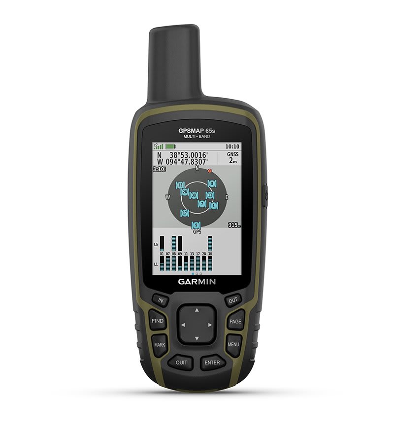
Multi-band technology and expanded GNSS support (GPS, GLONASS, Galileo, QZSS and IRNSS) provide optimal accuracy in steep country, urban canyons and forests with dense trees.
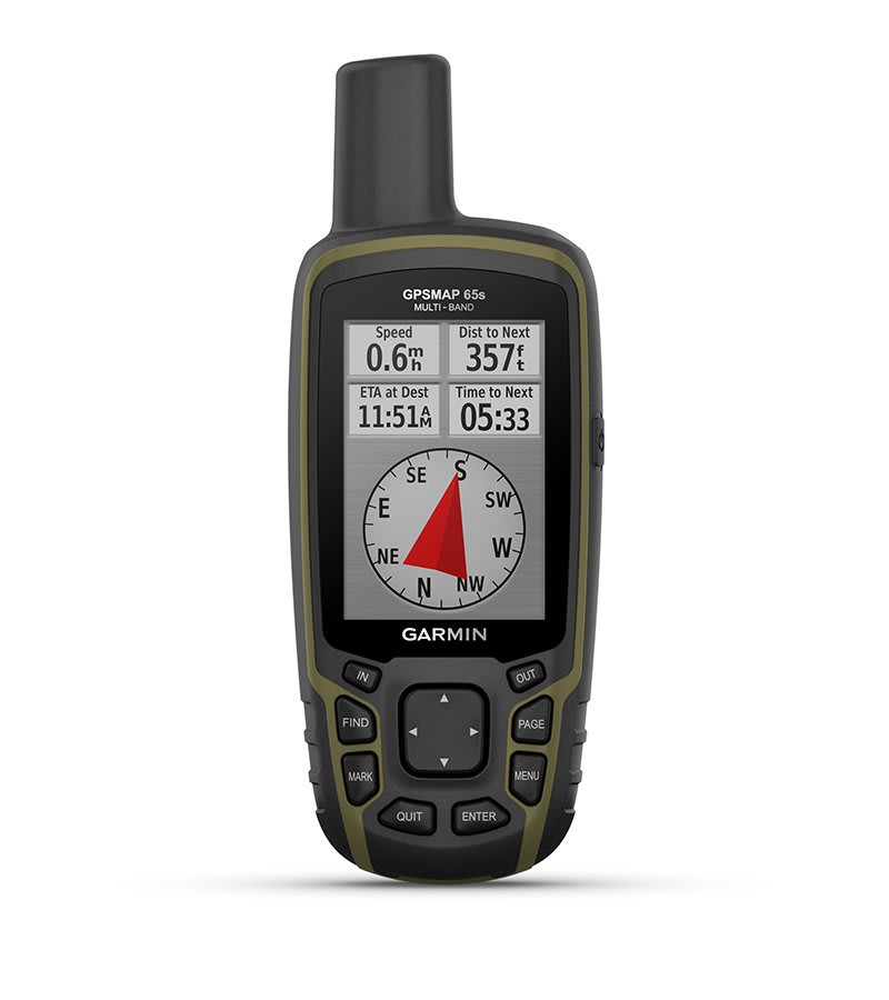
Navigate every trail with ABC sensors, including an altimeter for elevation data, barometer to monitor weather and 3-axis electronic compass.
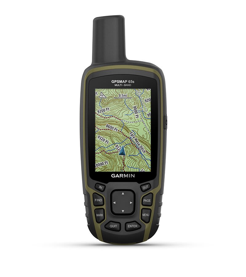
Preloaded TopoActive maps provide detailed views of routable street and off-road networks, waterways, natural features, land use areas, buildings and more.
Receive emails, texts and alerts right on your handheld when paired with your compatible device.
Plan, review and sync waypoints, routes and tracks by using the Garmin Explore app1 and website. You can even review completed activities while still in the field.
Get automatic cache updates from Geocaching Live, including descriptions, logs and hints.
General | |
| DIMENSION | 6.1 x 16.0 x 3.6 cm |
|---|---|
| DISPLAY SIZE | 3.6 x 5.5 cm; 2.6-inch diagonal (6.6 cm) |
| DISPLAY RESOLUTION | 160 x 240 pixels |
| DISPLAY TYPE | Transflective, 65K colour TFT |
| WEIGHT | 217 g with batteries |
| WATERPROOF | IPX7 |
| BATTERY TYPE | 2 AA batteries (not included); NiMH or Lithium recommended |
| BATTERY LIFE | 16 hours |
| INTERFACE | High-speed mini USB and NMEA 0183 compatible |
| MEMORY/HISTORY | 16 GB (user space varies based on included mapping) |
Maps & Memory | |
| PRELOADED MAPS | Yes (TopoActive; routable) |
|---|---|
| ABILITY TO ADD MAPS | |
| BASEMAP | |
| AUTOMATIC ROUTING (TURN BY TURN ROUTING ON ROADS) FOR OUTDOOR ACTIVITIES | |
| MAP SEGMENTS | 3,000 |
| SATELLITE IMAGERY | 250 BirdsEye Imagery files |
| INCLUDES DETAILED HYDROGRAPHIC FEATURES (COASTLINES, LAKE/RIVER SHORELINES, WETLANDS AND PERENNIAL AND SEASONAL STREAMS) | |
| INCLUDES SEARCHABLE POINTS OF INTERESTS (PARKS, CAMPGROUNDS, SCENIC LOOKOUTS AND PICNIC SITES) | |
| DISPLAYS NATIONAL, STATE AND LOCAL PARKS, FORESTS, AND WILDERNESS AREAS | |
| EXTERNAL MEMORY STORAGE | Yes (32 GB max microSD™ card) |
| WAYPOINTS/FAVORITES/LOCATIONS | 5,000 |
| TRACKS | 200 |
| NAVIGATION TRACK LOG | 10,000 points, 200 saved tracks |
| NAVIGATION ROUTES | 200, 250 points per route; 50 points auto routing |
Sensors | |
| HIGH-SENSITIVITY RECEIVER | |
|---|---|
| GPS | |
| GLONASS | |
| GALILEO | |
| QZSS | |
| BAROMETRIC ALTIMETER | |
| COMPASS | Yes (tilt-compensated 3-axis) |
| GPS COMPASS (WHILE MOVING) | |
| MULTI-BAND FREQUENCY | |
Daily Smart Features | |
| PAIRS WITH GARMIN CONNECT™ MOBILE | |
|---|---|
| SMART NOTIFICATIONS ON HANDHELD | |
| VIRB® REMOTE | |
Outdoor Recreation | |
| POINT-TO-POINT NAVIGATION | |
|---|---|
| AREA CALCULATION | |
| HUNT/FISH CALENDAR | |
| SUN AND MOON INFORMATION | |
| GEOCACHING-FRIENDLY | Yes (Paperless) |
| CUSTOM MAPS COMPATIBLE | Yes (500 custom map tiles) |
| PICTURE VIEWER | |
Outdoor Applications | |
| COMPATIBLE WITH GARMIN EXPLORE™ APP | |
|---|---|
| GARMIN EXPLORE WEBSITE COMPATIBLE | |
Connections | |
| CONNECTIONS WIRELESS CONNECTIVITY | Yes - Bluetooth®, ANT+® |
|---|---|